The Tropical Moist Forest (TMF) dataset provides unique information on tropical moist forest cover disturbances through an unprecedented dataset of maps of deforestation and degradation at fine spatial resolution (30m) covering the past three decades (1990-2020). The updated version of this dataset (up to year 2020) has just been released (14 June 2021).
For the first time at the pan-tropical scale, the TMF dataset identifies forest degradation in addition to deforestation and post-disturbances development stages.
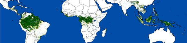
The study, describing the methodology and published in Science Advances, underlines the importance of the degradation process in such ecosystems as around half of degraded forests are subsequently deforested. According to the article, an estimated 17% of tropical moist forests have been lost to agriculture and other land uses since 1990. Of the 1,073 million ha remaining in 2020, 10% is degraded. The authors call for urgent action to safeguard tropical humid forests that are being subjected to alarming rates of deforestation and degradation (respectively 5.5 and 6 million ha on average each year). The methodology used to analyse the data is described in a JRC Technical Report. These TMF maps were presented to the tropical partners Users in the five REDDCopernicus regional workshops and were considered as key source of information on tropical moist forest cover dynamics.
The updated version of this dataset (up to the year 2020) is used in a new JRC technical report entitled “Deforestation and Forest degradation in the Amazon – Status and trends up to year 2020” that has just been published. This report (Beuchle et al, 2021) is aimed to clarify the definition, concepts and estimates on deforestation and forest degradation in this region.